


Clingmans Dome Road, which carries passenger vehicles to the Top of Ol’ Smoky, is expected to open to the public about 48 hours ahead of schedule this spring. Weather permitting, look for the gate to swing on the morning of Saturday, March 30.
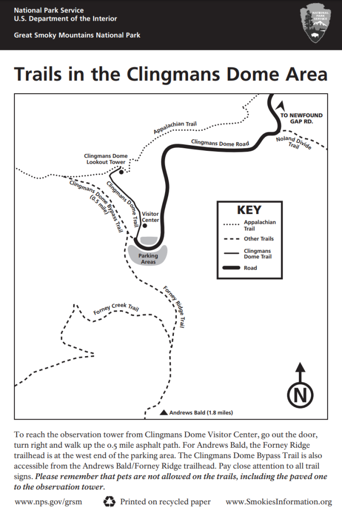
When you find yourself in the Clingmans Dome parking lot next, consider exploring one of our park’s shortest official hiking trails: Clingmans Dome Bypass Trail. But do yourself a favour – stop by the visitor center and request a free area map before you get started. Trust me, you’re going to need it.
The first time I hiked out to Andrews Bald alone, I was lucky. A hiker friend had forewarned me to pay close attention to how the trails of the parking lot are laid out and, more importantly, how they intersect with one another. Unfortunately, without the benefit of such sage advice (or a map), it’s all too easy to loose your way in this wilderness area. At best, your day stretches on longer than you anticipated and your muscles ache by the time you return to your car. At worst, getting lost can mean never returning to your car or your loved ones, as was the case this past September when a visitor died after loosing her way in this area.
When getting lost means loosing your life
From Great Smoky Mountains National Park: Great Smoky Mountains National Park officials announced last night (October 2, 2018) that search crews found the body of Mitzie Sue “Susan” Clements, 53, from Cleves, Ohio, after an extensive, week-long search. Clements had been missing from the Clingmans Dome area of the park since Tuesday, September 25. Her body was found off-trail in a rugged, heavily wooded area of the Huggins Creek drainage, approximately two miles from Clingmans Dome parking area and three-fourths mile south of the Appalachian Trail. A large-scale search operation was launched, which included trained searchers, canine teams, helicopters, and drones with advanced technology from around 50 local, state, and federal agencies and professional search and rescue groups.
Back to the Trail(s)
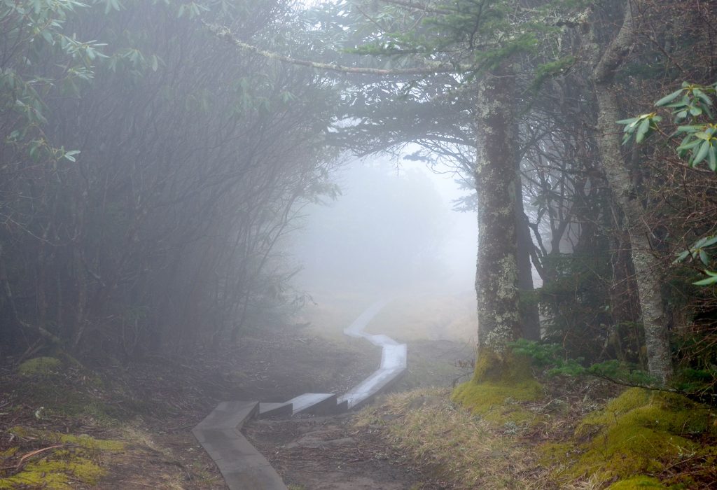
As its name suggests, this trail bypasses the crowds of folks huffing and puffing their way up the paved trail to the observation tower. It provides a quicker, quieter and more challenging access for those aiming for the Appalachian Trail. With your map studied and firmly in hand, start out by heading down the steps at the start of Forney Ridge Trail, on which the park’s very first Trails Forever rehabilitation work was completed several years ago. Down and around you’ll go, stepping over the result of hours and hours of work applied to this trail to make it safer and more sustainable for visitors.
Before you reach the intersection with CDBT after only 2/10 of a mile, I recommend you stop and take a breather. Notice how quiet it is even though a minute ago you were surrounded by hundreds of people in the parking lot. Notice how cool and moist the air temperature is, how sweet each intake of breath smells as it slips from your nose to fill your lungs. With little effort, you’ve found yourself at one of the highest possible elevations east of the Mississippi. Take a minute to enjoy the differences this environment provides.
Time to get going again… When you reach the intersection of Forney Ridge and CDBT and head in the direction the sign points you – toward the Appalachian Trail – you’ll quickly notice that you’ve started to climb. Your lungs will crave the perfumed oxygen and your leg muscles will burn. Keep going: Put one foot in front of the other until you reach the top. Your effort will be handsomely rewarded with views of Fontana Lake in North Carolina on clear days.
Now, at the AT intersection, is a good time to make yourself comfortable on the massive boulders you’ve discovered and consider your options for moving forward, for here is where a wrong turn can ruin your day. If your plan is to visit the tower for 360-degree views of this spectacular national park before heading back to your car via the paved trail, turn right. If your plan is to take the AT to the Newfound Gap parking lot and eventually on to Davenport Gap, turn right and simply keep walking past the tower and the crowds. If your plan is to head west toward Double Gap Springs, Silers Bald and eventually on to Fontana, turn left.
Or, if you’ve just realized that this is not the way to Andrews Bald, turn around and head back to Forney Ridge. Don’t be tempted to take Forney Creek Trail when you reach that intersection, but instead just keep going out Forney Ridge. You’ll know the bald when you get there.
And, worst-case scenario, if you’re hopelessly confused – with or without your trusty map – and you begin to worry this mountaintop maze might get the best of you, sit down on the trail, save your energy and listen to silver bell sounds of the dark-eyed juncos. Help is very close by.
Click on the map below to get the printable PDF version.