

By Elise Anderson
Kemp Writer in Residence
After attempting Ramsey Cascades as my first hike in the Smokies this year and turning around just ¾ mile shy of the top (wisely, or I’d have never made it back down), I decided to re-visit a classic for my second hike of the year: Laurel Falls. The 1.3-mile trail up to the waterfall is much easier than Ramsey Cascades, ranking at a difficulty level of 2 compared to Ramsey’s 12.
Because of the hike’s short length, easy, paved pathway, and the proximity of the trailhead to downtown Gatlinburg, TN, Laurel Falls is one of the most well-known and heavily trafficked trails in the Smokies. I remember picnicking at the falls many times as a child, but that was a long time ago, so I was curious how the trail might have changed over the years.
Fellow Kemp Writer-in-Residence Latria Graham and I meet up to hike to Laurel Falls and do a bit of comparative note-taking. This was her first time hiking this trail, and we were both interested in how our experiences of the hike might differ. I expected the area to be slammed, as my memories of Laurel Falls are cluttered with other tourists taking up the path, passing us, and waiting for one of the too-few parking spots near the trailhead.
The parking situation hasn’t changed. We waited beside the full lot, blinker-on, watching a family of four get into their minivan and ignore us for a solid 10 minutes while they looked over a map of the entire park. Once we finally secure a parking spot, we sat in the car and read through the Laurel Falls entry in Hiking Trails of the Smokies to prepare.
The last time I hiked Laurel Falls was some 15 years ago. As we started our hike, I recounted to Latria some specifics about this trail that have stuck with me since childhood: I remembered groups of people passing us as we walked, huge trees lining the path, and a paved, wide walkway that made it easy to hop, skip or run ahead of my family.
I didn’t remember much visibility as far as distance and height – I am pretty scared of heights, which hasn’t changed since childhood. I don’t have memories of being scared here by deep drops or super-narrow passages. I remembered reaching the top and wading in ankle-deep, cool water, looking for a decent-sized rock for a picnic. In my memory, I saw multiple families sitting on rocks at the falls, eating sandwiches with their bare feet in the water.
The first thing I noticed is how different the paved path is from my memory of it. The path is narrow – about a third the width of a one-lane road, but in my mind, it was a vast swath that could fit four people across. The trail hasn’t changed in that regard, though—I have. I’m much larger than I was the last time I walked this path, and perhaps much more aware of personal space than I would have been in my early teens.
As I thought about this, two children skipped around me. I hugged the inside of the trail, leaning on the mountain, as a young woman pushed a three-wheeled stroller with a newborn past me. Though part of me admires her strength, I was also a little annoyed; strollers are prohibited on this trail, for good reason. There’s really not enough room to wheel one past a hiker without forcing that hiker off the path, which is more dangerous in some spots of this trail than others.
I noticed the views more this time than I did as a child – the height of the steeper parts of the trail is clarified by the bare trees; we can see farther across and farther down than I ever remembered seeing. This is probably in part due to a perspective shift, and partly because my childhood memories of this hike are in summer when the trees are full of green leaves.
I’m glad I read the hiking trail guide before starting because it prepared me to notice subtle changes in plant life that gradually shift the scenery as the trail ascends. I had little trouble identifying the more Southern plant species at lower elevations; I recognize oak, rhododendron, birch, etc. from living in Florida and North Carolina most of my life. As we climb higher, however, different trees take over the landscape, transforming the scenery at the top of the trail into a much more Northern-looking forest.
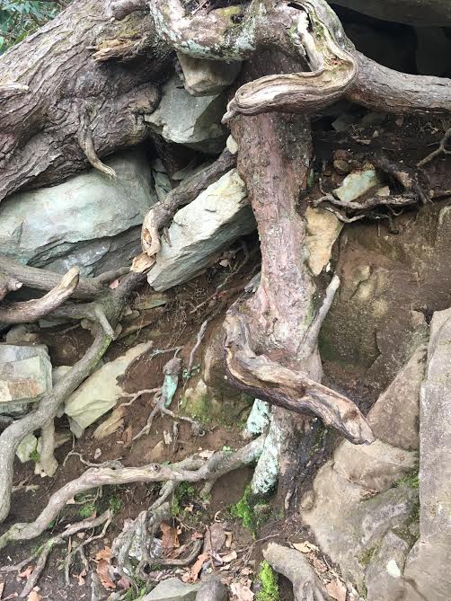
The highlight of my hike was the presence of a giant Eastern Hemlock tucked in the corner where the top of the trail meets the base of the upper falls. I spend a good 10 minutes staring in awe at a patch of its roots wrapped at eye-level around bare rocks, fascinated by how hand-like the roots look grabbing big hunks of rock. The thick, knuckled roots are so different from the lace-like delicacy of the tree’s needles, which filter the morning sunlight 60 feet or so above my head. It looked like this hemlock was holding the mountain in place and not vice-versa. But both statements must be true, at least here in the Smokies: the trees and mountains hold each other in place.
At the top of the falls, a new (to me) concrete bridge crosses the water. This was probably the most alarming discrepancy between my memories of hiking Laurel Falls and the current state of the trail and waterfall. There were no families picnicking on rocks, no need to take off our shoes (though we could have dipped our feet in if we wanted), and no spreading out of hikers across the shallow water here. The bridge was designed to help hikers cross the falls safely, but I can’t help feeling a bit disappointed and frustrated by its presence. It created a bit of a bottleneck, and it interrupted pictures of the falls taken from anywhere but the bridge itself. The child in me was disappointed to find a pre-formed, rigid structure where once I had to plan my own way across, albeit simple.
Standing on the bridge and looking out across the lower falls, Latria and I both noted a large number of downed trees. Their presence transformed the scenery from something that looked balanced and natural to something that looked almost tossed aside, like car parts in a junkyard. While not as picturesque as a postcard river scene, the area below the bridge strewn with fallen trees does provide ample seating for about 20 young people who sit, sprawl, kneel and straddle the logs casually, leaning across the water.
The last surprise for me on this hike was that I found there is more here than I remembered.
Literally. After the bridge separating the upper and lower falls (where I always believed the trail stopped), the trail actually goes on for miles. Learning this fact thrilled me because it added a new level of mystery to a place-memory I’ve held dear for decades. Imagine finding out there are more rooms in your childhood home than the ones you knew, or that your favorite restaurant serves a secret menu in addition to the meals you already know and love. Hikers visiting the falls can continue past the bridge for miles on an unpaved path that leads to the Cove Mountain fire tower and traverses even more miles to find themselves back at the Sugarlands complex of national park buildings. We considered continuing to the tower but decided to turn back as the impending rain clouds suggested exploring more might be a bad idea.
I know I’ll return in fewer than 15 years, and when I do I will hike farther and explore more than I ever have. For now, I feel relieved by how little Laurel Falls Trail has changed since I last hiked here. It’s comforting. And the falls are still so beautiful.
NOTE: Follow the GSMA’s Steve Kemp Writing Residents Latria Graham and Elise Anderson on Instagram (@GreatSmokiesWriter) as they explore the park in pictures.
Subscribe to get the latest posts sent to your email.


The Great Smokies Welcome Center is located on U.S. 321 in Townsend, TN, 2 miles from the west entrance to Great Smoky Mountains National Park. Visitors can get information about things to see and do in and around the national park and shop from a wide selection of books, gifts, and other Smokies merchandise. Daily, weekly, and annual parking tags for the national park are also available.