
In my history classes, I try to teach my students that, as much as maps can reveal about a place, they can also obscure other important information. For example, a political map of Europe just prior to World War I can help us understand the rivalries between the German and Russian empires, whose borders at the time touched each other. But that map also obscures the linguistic and cultural diversity of Central Europe in the early 20th century, home to Czechs, Poles, Slovaks, Ukrainians, and many other groups.
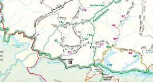
Well, this history teacher didn’t do a very good job of keeping that lesson in mind when planning my second multi-day backpacking trip in the Smoky Mountains. I really needed this trip to be a success—I was bringing along my best friend from college, who had done some day hikes with me, but had never spent a night in the backcountry. If I ever hoped for him to return with me, the hike had to be fun and rewarding. I mapped out a great “lollipop” route planned in a quiet corner of the park: We would leave out of Twentymile Ranger Station, spend the first night at campsite 113 on the Appalachian Trail (AT), enjoy Gregory Bald at campsite 13 the next night, and finish our adventure on Wolf Ridge Trail at campsite 95. A highlight would be the stunning views from Shuckstack Fire Tower on the first day.
When booking my backcountry reservations, however, I discovered that campsite 113 was closed due to bear activity in the area. Without much (read: any) thought, I quickly glanced at the trail map and chose campsite 91, a mere two miles or so off the AT, to spend our first night. It didn’t seem too far out of the way—a brilliant solution! We’d simply hike back to our original route the next day and continue with our loop.
One very important thing to know about the park-provided trail map, however, is that it does not render elevation change. On our first day, after 15 minutes of hiking straight downhill off the AT, we had grown mildly concerned about our return uphill the next morning. Forty-five minutes later, still descending the steep hillside, our mild concern had risen to near panic. What I had not realized was that campsite 91 sits at 2,040 feet above sea level—over 1,500 feet downhill from our junction back at the AT.
I won’t try to sugarcoat the truth: the next day was rough. Right out of camp, we had to climb back up the steep incline we had traversed the night before, then we ascended another 1,000 feet to Doe Knob. From there, we turned southwest and endured some painful ups and downs before finally collapsing into campsite 13 just as the sun was setting. At this point, I was fairly convinced my hiking buddy (who lost a toenail that day thanks to some ill-fitting hiking shoes) would never set foot in the woods with me again.
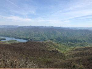
Fortunately, we had the same experience that most every backpacker has known: the pain in our backs faded away, our stiff and sore limbs loosened up, toenails regrew. Our memories of that hike focus on the positive: the twinkling lights of East Tennessee seen from Gregory Bald, our conversation over dinner with a hiker who had completed every single trail in Great Smoky Mountains National Park, the greens of early May emerging as we descended Wolf Ridge Trail.
I did, however, absorb the lesson I try to impart in my classroom: know the limitations of the map! While basic park maps provide an overview of trail and campsite locations, backpackers shouldn’t rely on them for navigation and planning. Instead, carry a more detailed map that includes information on the terrain, such as the GSMNP maps by National Geographic.
Every backpacking trip I plan nowadays begins with a clear-eyed assessment of mileage and elevation change. My hiking buddy is very grateful.
![]() Responders in the Smokies are typically called to about 100 search and rescue operations each and every year, but according to GSMNP Emergency Manager Liz Hall, most backcountry emergencies can be avoided by following the Smokies Smart guidelines:
Responders in the Smokies are typically called to about 100 search and rescue operations each and every year, but according to GSMNP Emergency Manager Liz Hall, most backcountry emergencies can be avoided by following the Smokies Smart guidelines:
S: Stay hydrated
M: Map your hike
A: Always wear proper clothing and footwear
R: Remember your flashlight
T: Turn back when conditions change
Hunter Upchurch is a high school teacher and college counselor who lives in Jackson, Mississippi, which is much too far from the Smokies for his liking. An enthusiast for all things related to the backcountry, he tries to spend as much time on the trails of Great Smoky Mountains National Park as possible.
Subscribe to get the latest posts sent to your email.