


As Hurricane Helene fomented in the Caribbean, it seemed likely that Great Smoky Mountains National Park would take a direct hit. The storm reached Category 4 before slamming Florida’s Gulf Coast, then headed north toward the Smokies.
But as it traveled, its course shifted east. Helene and its predecessor storm dropped unfathomable amounts of rain across Southern Appalachia—many places received well over a dozen inches in a matter of days, with some locations recording two dozen or more. The storm’s severity was unprecedented in the region, causing flash floods and landslides that have so far claimed at least 95 lives in North Carolina alone. Asheville, where extreme flooding destroyed entire neighborhoods and decimated the water system, logged a little over 14 inches between September 24 and September 28.
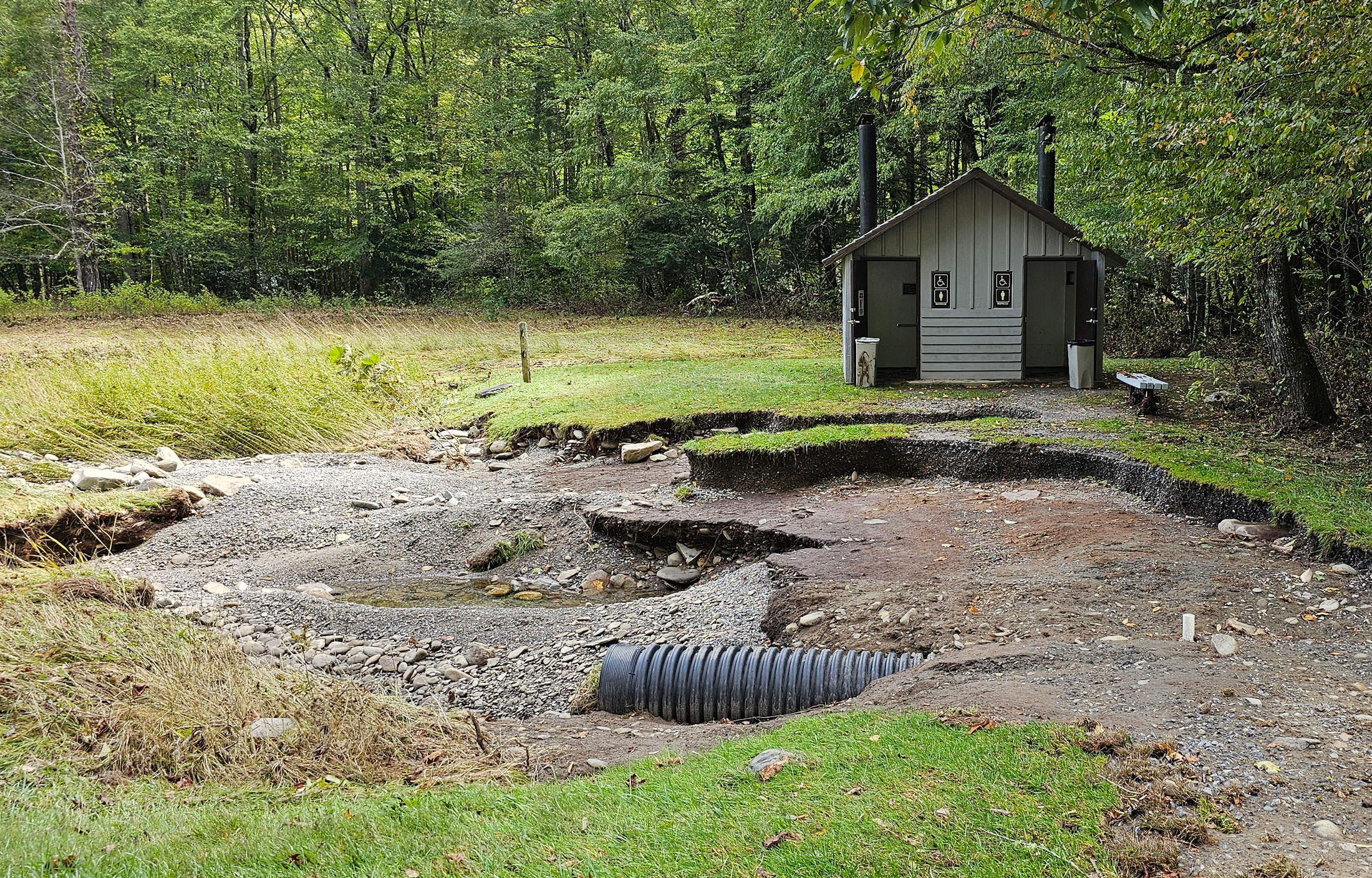
Most of the park fell far enough west of Helene’s path to escape with only minor flooding, but its extreme eastern region—Cataloochee, Balsam Mountain, Big Creek—was inundated. Record-setting rains tore out trails and roads and damaged historic buildings, leading the park to close these areas until further notice.
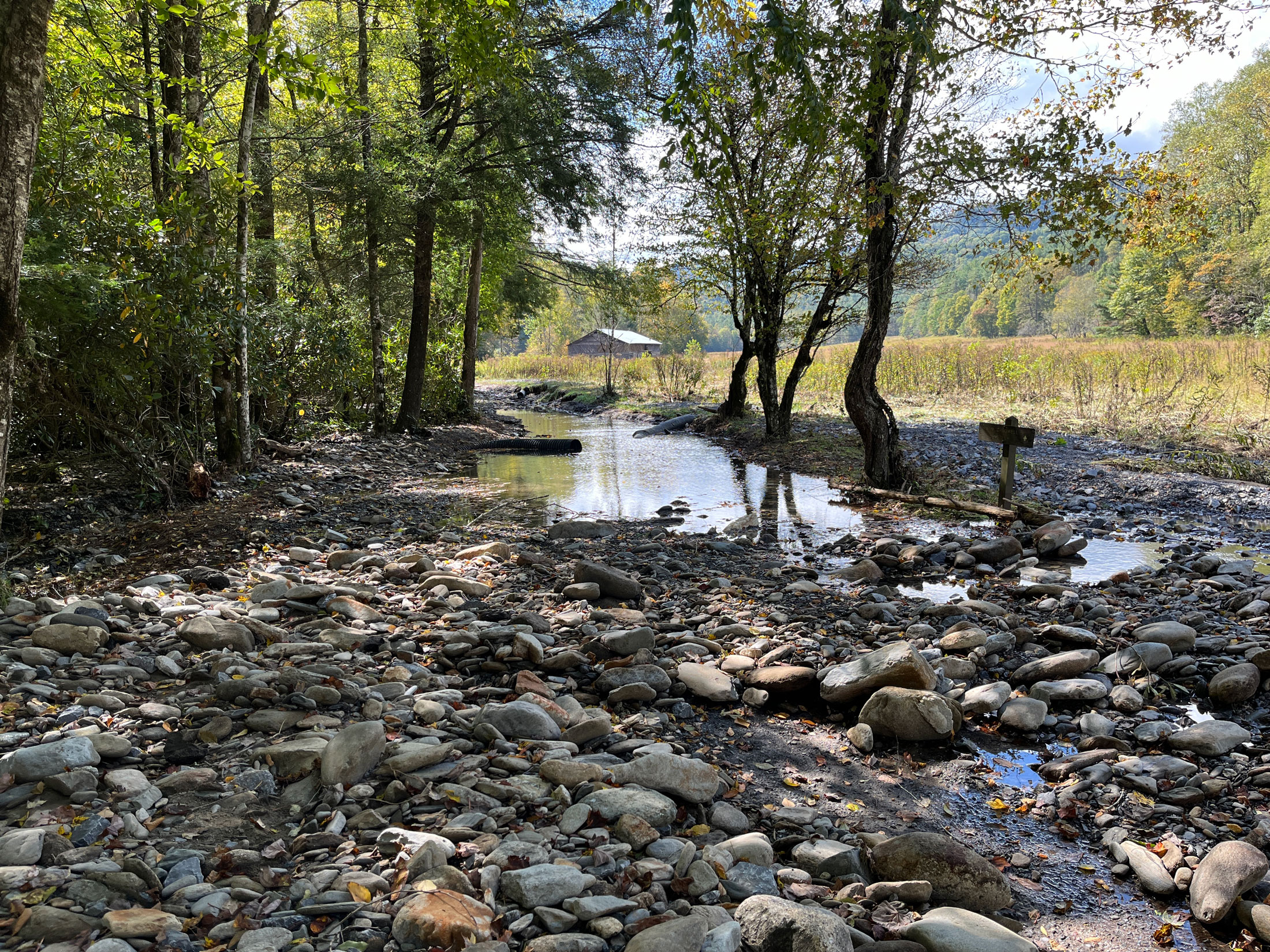
The worst damage unfolded in Cataloochee, a secluded valley in Haywood County, North Carolina, that is home to historic buildings showcasing the region’s pre-park history and one of the park’s two main elk herds. A US Geological Survey gauge on Cataloochee Creek located 3.6 miles north of Cataloochee Campground shows that the creek, which usually flows about two feet deep alongside the road, spiked to 9.5 feet September 27. That’s more than 17 inches higher than the previous record of 8.08 feet, set in 1963, said Matt Kulp, the park’s supervisory fishery biologist.
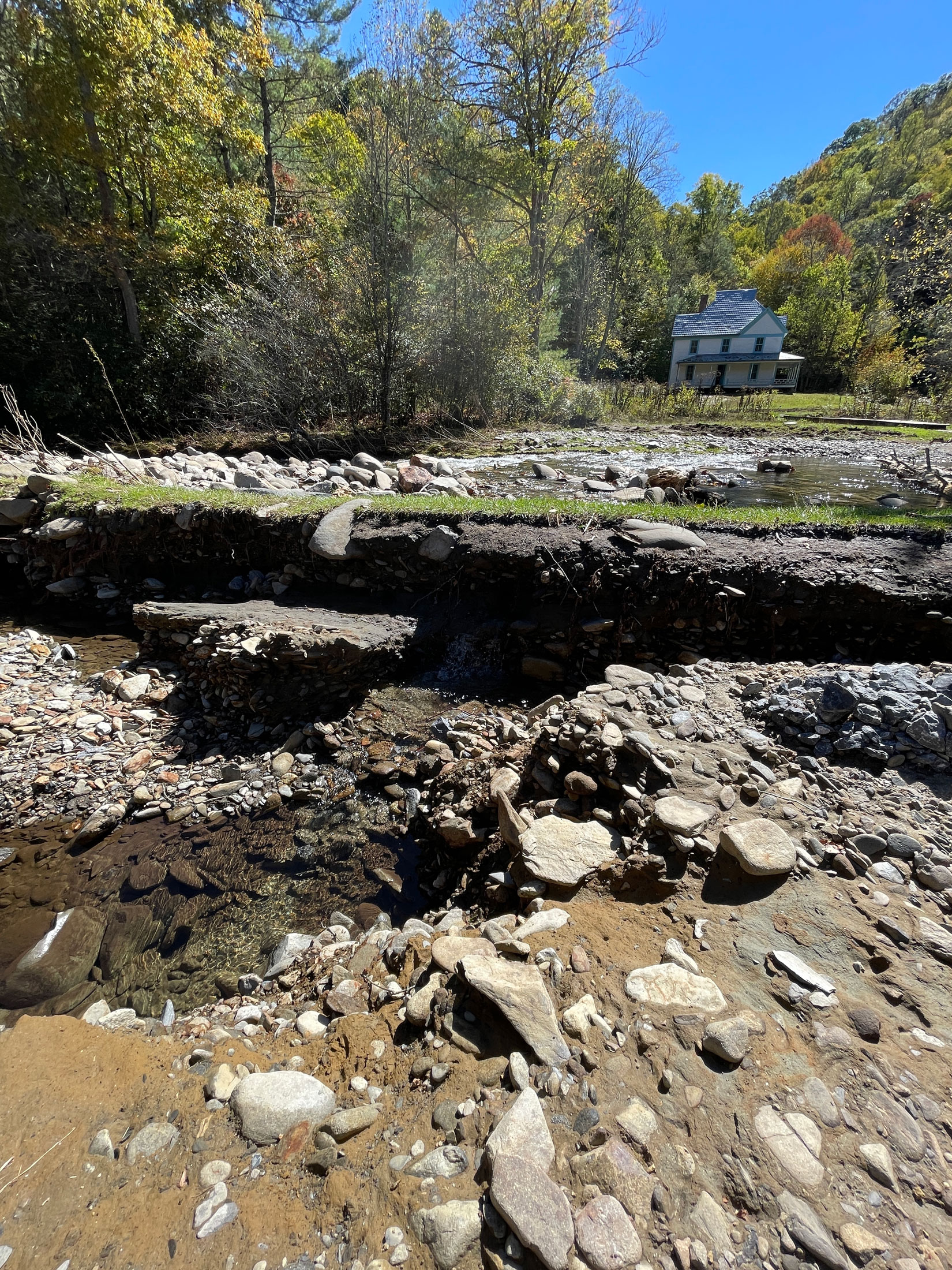
The flood’s aftermath is written most clearly on the valley floor, where the fields are full of debris. The far side of the creek, where the roots of the trees growing alongside it hold the soil in place, remained intact, but the road that borders the other bank is mostly ripped out and impassable to vehicles. In many cases, said Kulp, who visited Cataloochee October 9 to assess its condition after the storm, it’s deeper than the original creek bed.
“The far side had a root system in place, and the water just floated over it, whereas the road is like a weak spot,” he explained. “It’s right next to the creek, and so once water got onto it, it just ate down through it.”
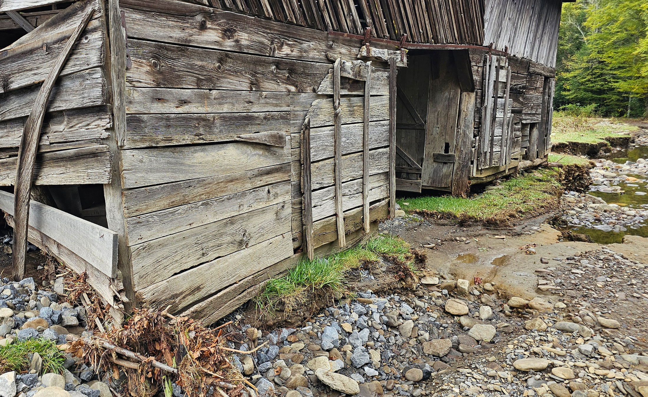
National Park Service photos show the roadway going past Caldwell House is now a gorge, and the rushing waters did severe damage to Caldwell Barn, which sits on the road’s opposite side. Park crews are working to stabilize the building.
“The water pushed in one of the walls on the upstream side, and it corroded out the footers—the foundations under it—so the corners aren’t sitting on anything,” Kulp said.
Before the storm hit, the Friends of the Smokies-funded Forever Places crew was working on a restoration project at the Steve Woody House, located in Cataloochee two miles down Rough Fork Trail. The house wasn’t damaged, but the trail was. The project is only about halfway complete, and the crew won’t be able to finish it until the trail is fixed.
According to Tobias Miller, the park’s roads, autoshop, trees, and trails branch manager, “all trails in the Cataloochee Valley have been impacted with various levels of erosion and flooding damage.” The two footlog bridges on Pretty Hollow Trail were the only ones that survived.
Just over the ridge from Cataloochee, Big Creek Trail took damage throughout its length, parts of it blown out so badly the park may need to bring in contractors to fix it. The fate of a 70-foot steel bridge that had crossed the creek five miles up the trail demonstrates the force of the flood. Both the bridge and its abutments washed away, and the steel beam was found downstream—bent.
Heintooga Road saw numerous washouts and slides along its length, as did Straight Fork Road, which starts just past the Cherokee fish hatchery on Big Cove Road. The footlog bridge on Swallow Fork Trail, one mile up from the junction with Big Creek Trail, washed away, and a significant landslide took out about 100 feet of trail tread on Gunter Fork Trail. However, many miles of trail have “really low impacts” with few downed trees, Miller pointed out. His team is continuing to assess trails in the eastern section of the park and to pinpoint the western extent of the damage. It’s unclear how long it might take to repair roads, trails, and bridges and allow the public back into these beloved areas, but addressing the damage is expected to take several months.
Even if Big Creek reopened today, the multitude of nearby road closures would make access difficult. Most visitors reach Big Creek by taking Interstate 40 to Waterville Road. Just below the power plant at Waterville, the Pigeon River jumped from its normal level of 4 feet up to nearly 22 feet before raging water displaced the gauge at 10 a.m. September 27. This part of I-40 has been closed since a swollen Pigeon River devoured entire sections of highway through the Pigeon River Gorge. No timeline is yet available for reopening, but the North Carolina Department of Transportation expects to award a contract for the road’s permanent repair by the end of October.
The implications of this closure stretch far beyond Big Creek. I-40 is a key corridor for travel between Western North Carolina and East Tennessee, and it’s the only road connecting Haywood County, North Carolina, and Sevier County, Tennessee, that is open to commercial travel. In the first five days after Newfound Gap Road reopened on October 2, 173 commercial vehicles were turned away after attempting to use that route. The road is too steep and curvy for large trucks, with no shoulders for large trucks to slow down or pull over, said Management Assistant Katie Liming. Drivers who violate the ban on commercial traffic can be fined up to $5,000 and charged with a federal misdemeanor.
“The key message is, it’s illegal and unsafe,” Liming said. “We understand that there are limited routes available, but the prohibition on commercial vehicles on that road in particular is really for the safety of all drivers.”
Despite extreme flooding that in some places resculpted creek beds within the park, Helene is unlikely to inflict long-term effects on the Smokies’ diverse assemblage of aquatic species.
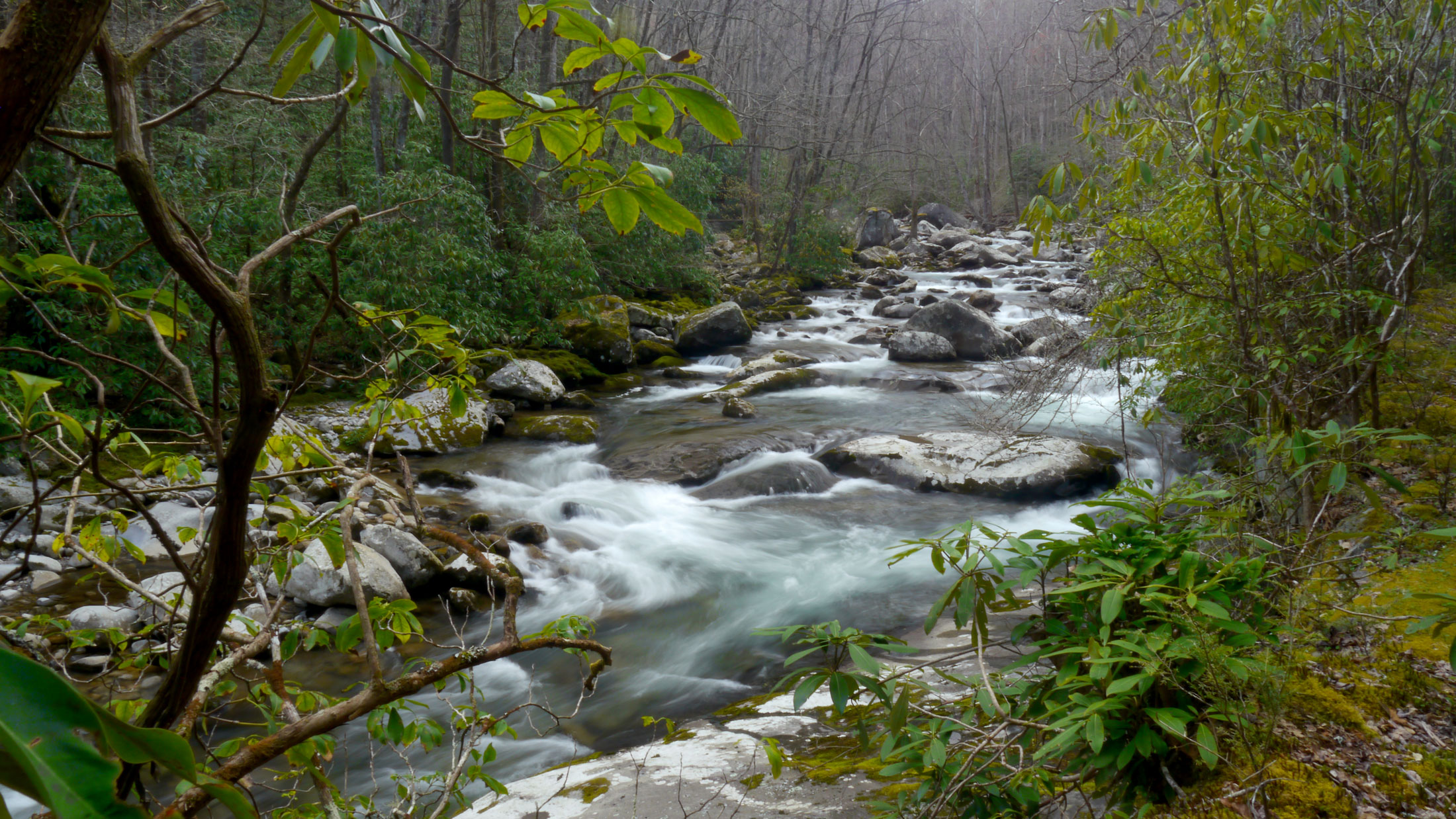
“Even in a major storm event, fish are pretty resilient,” Kulp said. “They’ve evolved with those things. People think they all get washed out, but they don’t. They actually survive them just fine.”
As a flood develops, fish and other aquatic organisms look for nooks and crevices along the bottom of the stream where they can hide, protected from the increasingly swift current. They ride out the storm in this relatively calm water and re-emerge when the storm passes. Extreme floods might rip away some of these safe havens, but not all of them. Kulp, who has been working in the Smokies for 30 years, said that the only time he saw a major decline in fish populations following a flood was in March 1994, when Little River took out large sections of Little River Road and Tremont Road. The adult trout population declined by about 50 percent but bounced back to normal within a few years.
More commonly, a severe flood might wipe out the youngest age class of fish if it occurs soon enough after spawning season to catch the fish while they’re still small and vulnerable. These small fish can get washed away, leaving a gap in the fishery’s age structure. Fish populations tend to recover quite easy from this kind of disruption—unless it happens repeatedly. Most brook trout get only one or two chances to reproduce in their lifetime.
“If we keep getting these extreme events at the wrong times of year, you can imagine it would only take a few years to eliminate age classes to where your population is going to be in trouble,” Kulp said. “And that’s a concern to me, because it seems like we’re starting to see more consistent winter and spring flood events of the magnitude that takes out young fish.”
Subscribe to get the latest posts sent to your email.